In the beginning, there were trails, and lots of them. New England was no “trackless wilderness” when the Europeans arrived—it was crisscrossed with paths laid out along riverways, up and down valleys, and through mountain gaps, used by the region’s original occupants for seasonal moves following food and for trading between tribes.
For the settlers, most of these trails were no-go areas, not particularly attractive or needed, given the at-hand task of establishing villages and then sticking close to them. Over time, however, colonists too sought trade routes, taking to coastal waterways, which offered the paths of least resistance. Despite their challenges, sea routes were smoother and quicker than roads, which were dirt or mud or worse, and petered out soon after leaving town.
Still, with an ox and a cart and a rutted track that connected the dots, passage between population centers became possible. Build a coach, add horses, and establish way stations that divided a long journey into stages, and now you could cover some real distances over land. The country’s first real stagecoach—called a “flying machine” and running between New York and Philadelphia—reduced travel time from three to two days.
Cut to the early 20th century and the arrival of the automobile. What started as an in-town novelty soon became a stampede of four-wheel ambition, and the region’s patchwork of local roads needed major improvement, and fast. Indeed, writes highway historian Richard Weingroff, “calling them ‘roads’ gives them more credit than they deserve. They were often little more than trails that were muddy in the rain and dusty the rest of the time. Any long trip by automobile required not only time, patience, and ingenuity, but tire-patching equipment, tools, spare parts, and emergency food and fuel.” A 1911 survey estimated that of the nation’s approximately 2.5 million miles of rural roads, only 10.5% were paved in any fashion.
In 1916, just eight years after the introduction of the Ford Model T, Congress passed the first of several federal highway acts, coordinating with the states to design, build, help fund, and—importantly--provide a coherent numbering system for a paved and connected system of interstate roadways. A welter of local signs and blazes, painted on telephone and power poles, gave way to the familiar shield of U.S. routes. North-south roads would be odd-numbered, east-west would be even. More improvements would come with time, culminating in the Interstate system we know today.
Examples of every stage of this evolution can be found across New England. What follows is a sampling of favorites, one from each state.
The Mohawk Trail (Massachusetts): So christened by the Massachusetts state legislature on October 14, 1914, before the federal system was put in place, it was the among the country’s first “scenic highways.” More romance and marketing than fact, the road only occasionally follows the earlier Native American trail, which was used more by local Pocomtucks than by the fierce-sounding but upstate-New-York-dwelling Mohawks. A roadside-attraction holdover, the Trail is replete with theme-appropriate “Indian trading posts” and the kinds of small hotels, motels, non-chain restaurants, and camping grounds that were common in the early days of motoring. While most of these have seen better days, the 63-mile road still impresses, from the dramatic French King bridge 140 feet over the Connecticut River, past the hipster haven and Bridge of Flowers of Shelburne Falls, through the wild and forbidding Cold River gorge, and over the mountains to the cultural wonders of North Adams and Williamstown.
Scenic Route 1A (Rhode Island): A legacy of New England’s early, unorganized roads, this state route is a hash of signage and routing that overlaps and disengages from U.S. Route 1 in four distinct sections as it wends 39 miles along Rhode Island’s coast. When “in concurrence” with Route 1, its signs disappear; when separate, it’s a pleasant, salt-air ride along surface roads past beautiful beaches, marshland, and wildlife preserves. It takes you to Point Judith, with its 1816 lighthouse, and Watch Hill, which, according to the New York Times, “impresses visitors with a strong sense of privacy and of discreetly used wealth - the rambling, old-fashioned, turreted and gingerbreaded Victorian summer houses with piazzas and softly rolling lawns have little in common with the overpowering castles of the very rich in Newport.”
U.S. Route 5 (Vermont): One of the first designated “U.S. routes” resulting from the federal Highway Act of 1921, Route 5 runs down the entire Connecticut Valley from Derby Line, Vermont, to New Haven, Connecticut. Its drivers are hardly the first to travel the natural contours of the land. Native Americans fished at Bellows Falls, and left petroglyphs depicting human (or spirit?) faces along the banks of the river. Just up the road is Windsor, where in 1777, Vermont was declared an independent republic. It didn’t last long (Vermont being the first state admitted, in 1791, after the original 13 into the new United States), but its constitution was the first document in America outlawing slavery and granting universal male suffrage without property requirements. Also in Windsor is the American Precision Museum, a fascinating spot dedicated to machine tools and the mass production they made possible, housed in an old armory whose repeating rifles’ quality so amazed the British Army that a Parliamentary commission came over to study how it was all done.
The Merritt Parkway (Connecticut): It didn’t take too long for the original federal routes to become clogged with traffic, U.S. 1 and its endless conglomeration of gas stations, diners, billboards, and stop lights being a prime offender. Limited-access parkways like the Merritt were developed in the 1930s, stressing aesthetics over tack and speed over consumer choice. Every bridge spanning it boasted a unique design, and its six service plazas had parking lots, gas stations, and convenience stores so that drivers wouldn’t have to exit to refuel or refresh. The forest it passed through was so much a part of its character, with trees in the median and close to the edges, that some argued they were more a hazard than a feature. A Connecticut study showed that from 1985 to 1992 about ten people died every three years in tree-related accidents, far more than on the average state road. Today, aggressive tree trimming and improved exits and entrances make the parkway safer, though its landscape-hugging ways still thrill.
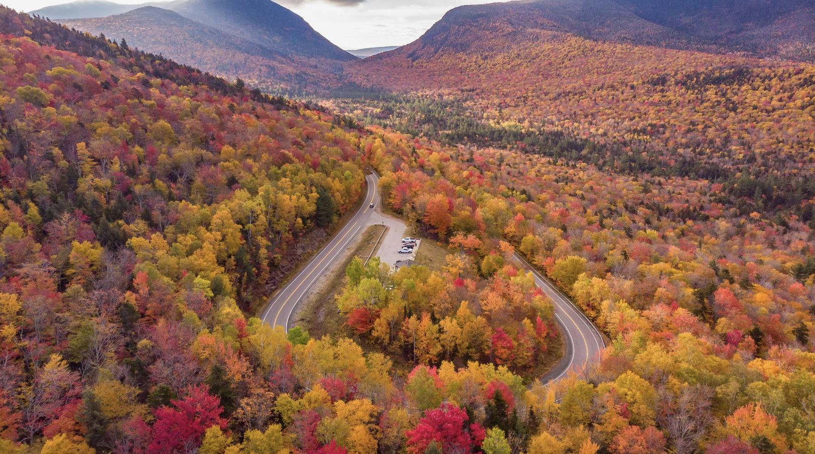
The Kancamagus Highway (New Hampshire): For real driving thrills, however, the “Kanc” has few New England rivals. Officially designated a National Scenic Byway by the U.S. Department of Transportation (there are only 120 in the country), it’s a twisting 56-mile romp through the White Mountain National Forest, hitting an elevation of 2,900 feet on the flank of Mt. Kancamagus near Lincoln. No gas stations, restaurants, or hotels clutter the breathtaking views of rushing rivers, deep gorges, and mountain vistas, and six campgrounds and several hiking trailheads make pulling over a must. Crowded during the fall with leaf peepers, it’s a driving enthusiast’s paradise at other times of the year. Cambridge realtor West Bigelow recently took his sports car up for a spin. “I’d been on the Kanc when I was in high school and it stuck in my head,” he says. “Getting out there as an adult—always abiding the speed limit, of course—was the best driving I’ve ever experienced. The road is beautifully maintained and the curves are incredibly seductive.”
Interstate 95 (Maine): The Interstate Highway System was authorized in 1956, and thanks to it (depending on your point of view), one can cross the country without seeing a stoplight. Also known as the Dwight D. Eisenhower National System of Interstate and Defense Highways, it spawned several popular myths, including the one that says that one in five miles is straight so that military planes can land in emergencies. In Maine, I-95 above Bangor transformed the northern tier of the state from nearly inaccessible to easily traversed, bringing the glories of Baxter State Park within striking distance of major cities and cutting travel time across the interior so much that the old joke of “you cahn’t get there from hyah” no longer resonates. With a speed limit of 75, it offers a high-speed ride through majestic forested spaces and so-called unorganized townships that make the word “rural” seem inadequate. One, called T1 R6 WELS, holds a glorious overlook: rising up across Salmon Stream Lake is Mount Katahdin, centerpiece of Baxter, northern terminus of the Appalachian Trail, and one of the most dramatic sights in all of New England.