Liquid Asset
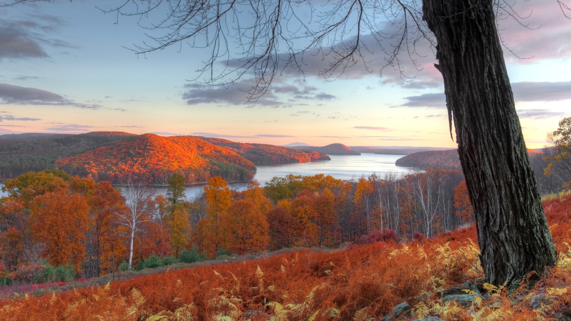
The Quabbin Reservoir covers 38.6 square miles of central Massachusetts and is arguably the largest single manmade object in New England. Filled with 412 billion gallons of unfiltered water “of an almost prehistoric clarity and taste,” as author Thomas Conuel describes it, it’s more than a supply vessel for 2.5 million people in Boston and 48 other communities. It is, he says, an “accidental wilderness” that mixes a lost world’s melancholy with striking natural beauty.
How it came to be was no accident, however: Boston was thirsty and four towns — Dana, Enfield, Greenwich, and Prescott, with about 2,500 residents living, working, and otherwise enjoying their liberties — were literally washed out to provide the city with water.
Since its founding, Boston was continuously outgrowing its water supply. The natural springs and wells could not keep up with a rising population and the pollution of outhouses and animals, so in 1796 the city tapped Jamaica Pond in the hinterlands of what was then Roxbury, with wooden pipes distributing clean water to a pleased populace, or at least those who could afford the service. But while the little pond could handle the city’s daily per-capita use of about 10 gallons (today’s is around 110 gallons), the introduction of indoor plumbing in the mid-1800s sealed its fate as a workable water supply.
The solution came by way of Lake Cochituate, 17 miles west of the city, and the Sudbury Reservoir, about 25 miles out. These sources lasted till they too proved inadequate, though two of their aqueduct bridges leading into Boston remain: the 1848 Cochituate Aqueduct crosses the Charles River in Newton and can be spied just off I-95 South, while the 1878 Echo Bridge from Sudbury is the centerpiece of Newton’s Hemlock Gorge Reservation. (The Sudbury Reservoir is still an emergency back-up source of drinking water.)
Boston’s population grew by 50 percent between 1890 and 1920. By 1895, the water engineers were looking further west, specifically to the Swift River Valley, a natural bowl surrounded by 400- to 600-foot-high hills, with clear rivers and streams running into it. As Conuel writes in his book Quabbin, The Accidental Wilderness (University of Massachusetts Press, 1990), the area, 65 miles west of the city, “needed only a little human handiwork to create a gigantic water supply.” However, it would take a major exercise in eminent domain to deal with the valley’s four towns and all that went with them. Turning Lake Cochituate into a reservoir had involved moving a few houses back from the edge of the water; this scheme would require the complete obliteration of entire communities and a way of life. In addition, the state of Connecticut was none too pleased with the capture of water headed for the Connecticut River. As alternative ideas such as the treatment and diversion of just about every river in eastern Massachusetts ran out of steam, a lawsuit brought by Connecticut was settled and the Quabbin project was authorized in 1927.
The building of two main dams was accompanied by the sad work of clearing the valley of its structures, railroad tracks, vegetation, and inhabitants. Post offices closed, then schools. Finally, by the spring of 1939, there was no one left. Homeowners were paid for their property. 7,613 graves were identified and moved to higher ground (the majority into the new Quabbin Park Cemetery in nearby Ware). Crews burned brush and fed trees into 15 sawmills; the very loam was scraped up and taken away, and more than 1,000 buildings were either moved, dismantled for salvage, or torched. Even the fish in the ponds were taken away, so that fishermen elsewhere in the state could catch them. Finally, by the spring of 1939, there was no one left, only a denuded landscape made as sterile as possible in preparation for holding clean water. As New Hampshire writer J.W. Ocker puts it, “These towns were drowned so that Bostonians could bathe.”
Flooding began August 14, 1939. It took seven years for the reservoir to fill, but the metropolis began drawing water in 1941 and still does to this day. To get the precious commodity to its destination, it first heads down a shaft under the reservoir’s east side and into a 12-foot-diameter aqueduct blasted into bedrock as deep as 657 feet and running 24.6 miles to Wachusett Reservoir, which in turn supplies the end users in Eastern Massachusetts. The system is run by Massachusetts Water Resources Authority in conjunction with the state’s Department of Conservation and Recreation.
Today, one of the most popular trails in the 55,000 acres surrounding the reservoir leads to the Dana town common, which mostly escaped submersion. There the foundations of homes, the school, town hall, and the old Eagle Hotel are made more ghostly by the black-and-white photographs mounted near them, showing the buildings as they once stood. (Park at Gate 40, off Route 32A in Petersham, Massachusetts, and walk 1.7 miles down Old Dana Road.)
The reservoir itself is clear and wild, surrounded by forested hills and home to coyotes, deer, loons, and eagles. J.R. Greene, chairman of the non-profit Friends of Quabbin and author of 16 books about the reservoir and the towns it replaced, points out the island where officials once proposed a rattlesnake reserve. “It wasn’t a great idea,” he says. “They can swim, and with all the hikers and bikers that come here, one bite is all it would have taken to get the state into a lawsuit.” Fishing is also allowed — although the state stocks the reservoir, it’s nice to imagine that a few species escaped the 1930s clearance.
Greene looks down the crumbling old-time macadam of former Route 21, which runs through the quiet woods and heads directly into the water. It reappears about 15 miles to the southwest, emerging from the reservoir near Belchertown. “That road used to run through North Dana, Greenwich, and Enfield,” he says, and I think how much more there is to a glass of water than most of us realize.